
Kayaking Rivers in Ecuador

get access to 80+ sections and rivers in Ecuador.
Download the free whitewater river guide app in your phone, Ecuador best and more complex guide of rivers with maps, coordenates, logistics, contacts, photos, videos, and all the information you need to have an epic whitewater kayaking trip in Ecuador.
https://whitewater.guide/
< CHECK OUT THE VIDEO PAGE FOR MORE INFORMATION ON NEW RIVERS AND RIVER DESCRIPTIONS >
We have it all when we talk about rivers and whitewater, the high concentration of rivers in such a small area with the extreme geography and amazing geology makes of Ecuador one of the top 5 world's best whitewater kayaking destinations. Everyone has fun here from beginners to pro's, you decide how much fun and how big you want to go. In general you will find continuous whitewater, pristine, clean, round boulder gardens with endless fun and boofs. There are so many rivers to choose from once you are down here it's just amazing and all depends on the amount of precipitation. We are usually more concerned about having too much water!!
The Andes split the country in 3 main regions, Costa Sierra and Oriente this last one being the on the East slopes of the massive mountain range are the headwaters of the Amazonas river the biggest volume river in the world, all this water coming down from the Andes are part of our playgrounds and the best and closest place for any kayaker that come to visit Ecuador.
The Coastal side starts running in FEBRUARY and provides with some world class kayaking for all styles of boating. Water quality is not that good but if you stay on the upper runs you can have a great time.
Kayaking goes year around but a most kayakers visit Ecuador between Oct-March, the amounts of precipitation are variable but there is always kayaking.
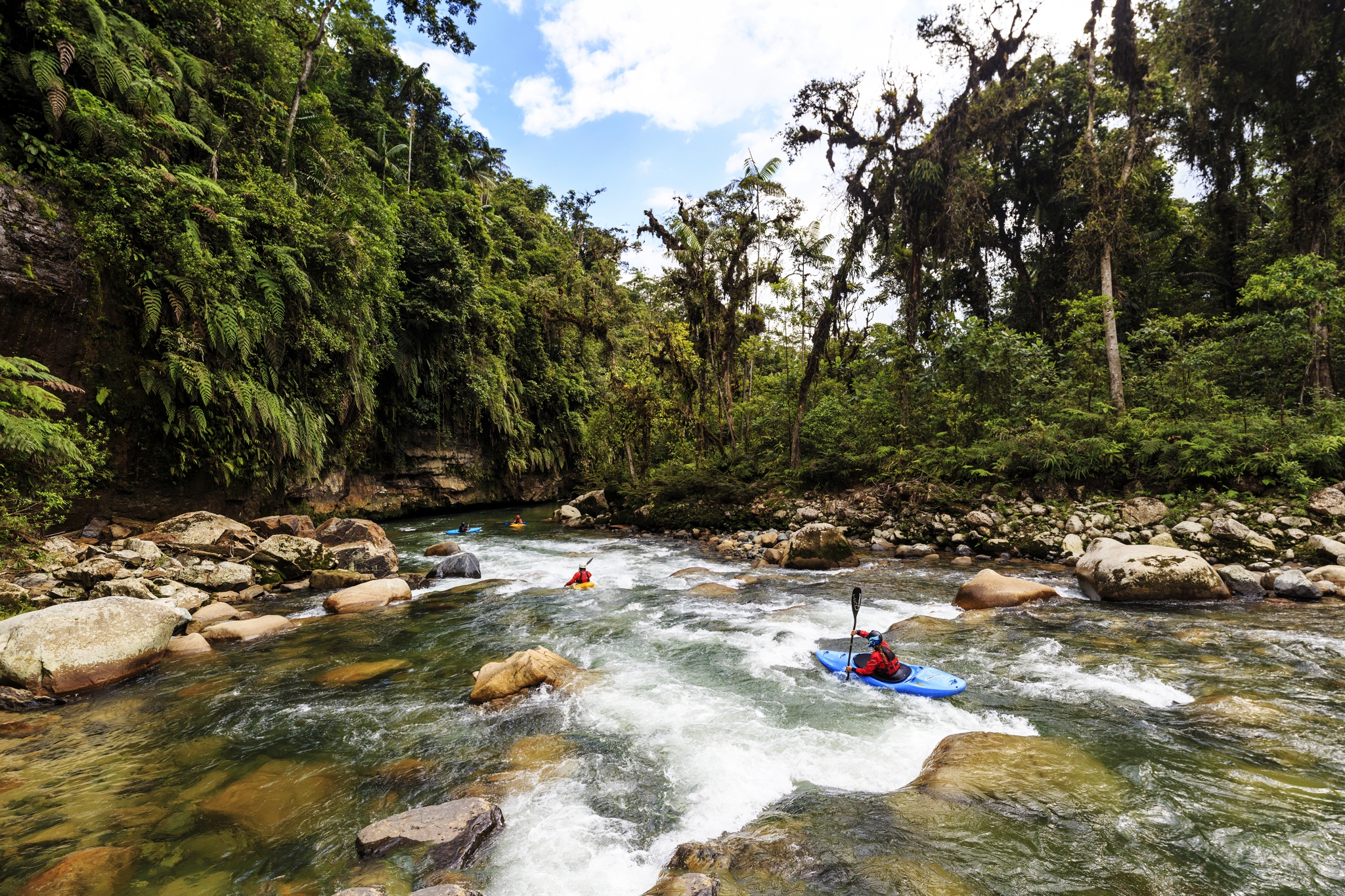
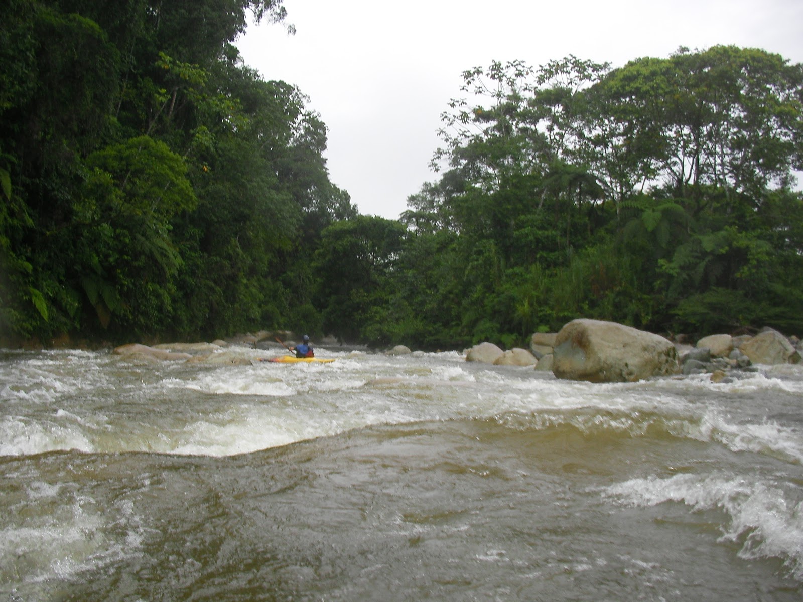
The Quijos Valley keeps good water levels for most of the year and is the most popular hub for whitewater kayakers in Ecuador. Tena is only 2 hours away south east dropping into the tropical jungle to 1500 feet (600m) where water is warm and weather is HOT.
Baños has a lot of good steep creeking, big volume and remote runs, and also delivers a very rowdy party scene.
The Quijos Valley- paradise for all religious kayakers
(Go to Church everyday)
East from Quito as soon as you start dropping down the Andes towards the Amazon basin quickly you notice some amazing whitewater in the creeks along the road.Soon the volume and steepness of the river changes and what you see now is the Quijos River that comes down from the east side from the glaciers of the Antisana Volcano and here we start to recon many sections for over 100 km.Make a priority to come here first since is so close from UIO international airport, the whitewater here is amazing and abundant, this is kayak central, here you can hook up with more kayakers easily and get hooked with any logistics you may need to keep on moving, you have Hostels,food, shuttles. Makes logistics easy. The Quijos river runs North along the road to Coca, making the logistics really easy for most sections, here you can start warming up on the to get use to paddle at 6000 feet elevation, before you venture into the most difficult runs. Water on the Quijos come from the glacier of the majestic Volcan ANTISANA and at this elevation water is a little chilli but a drytop is enough for most paddlers.
Class IV for miles with class III in between the stouts. Miles of steady gradient provides endless fun.
View Larger Map
Papallacta River V-Quijos IV/IV+Cosanga River IVOyacahi River IVBorja Creek III+
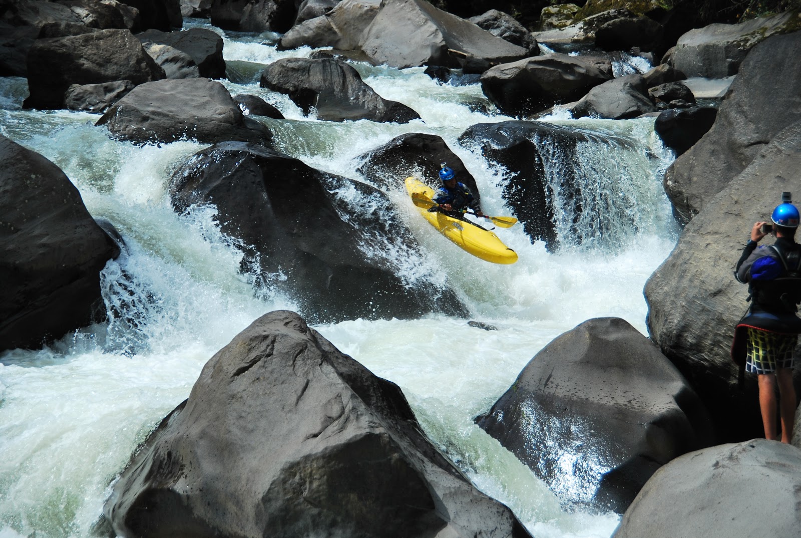
Rio Quijos, Class III-IV-V
Cheese House IV/VBridge to Bridge IV-/IV+Baeza to Borja III/IVBorja to Chaco III/IV ( The Chaco Canyon Section)Chaco to Salado III+/IV (The Bonbon Section, epic Canyons big water)Salado to San Rafael III+ IV huge water
The Quijos has it all! Close to the town of Baeza, and only a couple hours from the UIO international airport the Quijos starts out technical and steep and quickly grows in size as feeder streams pour in out of the Andes. The majority of its runs are located upstream of 475-foot San Rafael Falls, one of the biggest waterfall in the country. The river's characteristics change as you keep going down starts steep and technical and ends up being really big and fun. In all, the river offers about 100 km of whitewater offering several sections, most have good access. Most of the bigger-volume sections below the confluence of the Rio Cosanga have great play spots and are pool/drop in nature.
OK lets start with the upper sections:
Papallacta creek Class IV/V
Steep quality creeking, soon to be diverted and de-water for hidroelectric and drinking water for Quito.
30 minutes uphill from Baeza on the way to Quito, is the town of Cuyuja, there is easy access to the river and a gage just downstream of the bridge. (river right). I've run this down to is lowest but I don't recommend it less than 5 , it does go but is very boat abusive and easy to pin. 6-7 is perfect. and have only run it up to 9 (stout).
Steep and technical Part of the head waters of the Quijos. The first mile will tell you all about it, is continuous and it goes well, boat scouting is doable, soon starts showing canyon walls and gets boxed in a couple spots, scoutable and good to go. There is so many rapids that you will loose the count, the whole run is fun non stop boof after boof that will keep you in your game. Only a couple rapids have names on this section everything else is buggy.
put in rapid. 7.5 on the gage and raising.
we call this one vietnam, 3/4 of the way down. highlight of the run!
the middle of the canyon has this stout, easy to scout on the left 1/3 of the way.
Confluence rapid. totally changed now after some blasting and tractors. will never look like the picture again.
After this rapid you can take out if you had enough or continue on the next section , bread and butter of every day when you are hanging out in Baeza." LA CASA DE QUESO" pretty common to do both sections. (long day)
CHEESEHOUSE from BOOF SESSIONS on Vimeo.
The CHEESE HOUSE class IV+/V feels big and pushi from the beginning, is a in your face kind of warm up. Boat scouting is easy at lower flows, pretty continous rapids specially at the begining, the very first rapid is a man made rapid so be very careful some blasted rock makes some sharks here. I've seen a few people pinned here trying to sneak it, this rapid changes after every flood.
"Hecho en Ecuador" (made in Ecuador) FEB 2016 pretty clean down the middle. The next half mile is really fun and non stop stout, quick you will notice a very significant drop that deserves to be scouted. The middle has a very nasty hole that at all flows is a most BOOF!!! called "duss boof" , soon to be named "duss swim".
make sure you boof this one, !There is some in fun buggy in between the bigger rapids here until you get to the power house, or Sunshine Left.
The next significant rapid is called laberinto, water gets shallow and you find yourself in the middle of the river trying to find the deeper channel, left side is junky and piton rocks wait at the bottom, river right channel will give you a surprise with a stout entrance, this is the main line and the lead in towards a big one, enter on the center and cut all the way back to the left.
From here down is super fun with one more significant rapid Piggly Wiggly, totally changed form what it used to be, still a really fun and big rapid.
Take out at the first car bridge you see, or continue to the next section : PUENTE A PUENTE
BRIDGE 1 TO BRIDGE 2
2016 Quijos River Festival organized by boof Sessions, thanks for all the support from Gina's Restaurant, Casa de Rodrigo , ERI Ecuadorian River Institute and Baeza municipali Bridge to bridge was the place to have a great race for the festival on the first weekend of the year.more pics at :
https://m.flickr.com/#/photos/bdj238/23808792414/in/set-72157663577441616/
Save the date: first weekend every year with the festivities of Baeza . QUIJOS WHITEWATER RIVER FESTIVAL
The Bridge to bridge is a good warm up for the Cheese House. Solid class IV rapids with continuous characteristics and awesome boofs.
Bridge 2 ( Puente Quijos 2) is your take out unless you are going to Borja. Then you are on the
BAEZA-BORJA .
RIO BORJA:
RIO BORJA.- when everything else is too big, Borja still delivers a short and sweet option on this continuous rollercoaster.
CHACO CANYON:
El Toro rapid in the Chaco Canyon.
Rio Cosanga, Class III-IV+
3 sections: Upper upper, upper, lower (canyon)
Classic run, another feeder of the Quijos, this river is south of Baeza on the way to Tena. It's always good. There are three runs on this river, including a hard-to-find section just above the town of Cosanga for when it is really high. The upper starts in the town of Cosanga and starts with some class III-III+ rapids and 1 stout class IV+ totally portageable on the left, it will give you a good feel for what's to come below on the lower section. when it turns into a class IV, IV+V at higher flows.The lowest and hardest section of the river carves through a couple canyons with a pool drop feel is certainly a beauty of Ecuador's whitewater.
Rio Oyacachi, Class IV/IV+
This river flows into the Quijos from the west and is a continuous boofarama technical run. It can be boated from 200 to 2,000 cfs. The entire run from the town of Oyacachi was first done in 1997 and very seldom repeated since then. This is a very remote and difficult 3 day run starting high in the Andes and ending up at the Rio Quijos. The normal run is a fun Class IV section above the confluence of the Rio Quijos. It has beautiful, clear water with big granite rocks and continuous technical rapids. (boof session)
between the Quijos Valley , on the way between Baeza to Tena you have several options:
Rio Jondachi,
The UPPER , Class IV+/ V
Paddle in from the km 28 put in or Hike in at la Merced de Jondachi km24 , into the top 3 best runs for your trip.
Sideways boof, another classic run for Ecuador's whitewater.
3 huevos Running out of the (Macaw) Guacamayos WA-KA-MAYOS mountains off the flanks of the Sumaco volcano, the Jondachi offers the most fun continuous creek-like kayaking and is one of the Classics. It has 3 sections . The upper section is a fantastic class V run that will keep the most experienced kayakers on top of their game for several miles with big moves and boofs all over the place and maybe a couple easy portages. The middle section is a long day because needs to be combined with the lower to avoid a hike out but is a lot of fun and very scenic with many waterfalls that feed into it both sections have a remote feeling, the upper portion is next to be dammed unfortunately.
put in rapid
MIDDLE Jondachi Class IV
Get ready for the most amazing jungles and endless boulder gardens, great option for a lower water day and the upper is a little too low, and it will be full on at higher flows.
Lower Jondachi-Hollin section class III-IV
Gorgeous tropical jungle paddling Starts a little technical for the first half of the run until the confluence with the Hollin, then the water gets bigger and turns into a wide river, very scenic and pristine jungles and lots of waterfalls on the sides from the side creeks.
Rio Hollin Class IV-III
The Rio Hollin starts out small with a creeky feel,but it can be a raging torrent by the end of the two-day trip if it's raining. Be prepared for water levels to change and don't be lulled by the river's initial creekiness. Though the run doesn't have many places to camp. Most campsites are close to the water, so if it rains be prepared to retreat to the rain forest to escape high water. Above the put-in are a few waterfalls that are spectacular drops but most paddlers stick to the tried and true section. The run's highlights include a 10-foot waterfall and the chance to paddle a Class IV rapid through a cave.
kayaking out of the cave rapid on the first day of the Hollin whitewater expedition style Tena
Upper 'Mis' creeking in Ecuador lodo section
Welcome to the jungle!! we are gonna make you scream! If you're looking for hot weather and warm water paddling this is as good as it gets. The rivers here fan out around town making of Tena one of the country's most popular regions for warm water kayaking.
Rio Misahualli, Class -III/IV+
upper Misahualli (Miss)Upper misahualli from Cotundo bridge down
The upper runs on the 'MiS' are steep, tight, round boulder-choked and technical. The upper runs are worth the muddy walk for a couple extra miles of quality steep creeking. the intensity of the river comes down as you come closer to Archidona, where you want to take out.
Below Tena, the Rio Hollin joins the Misahualli and the run becomes a Class IV big-water, pool-drop river with lots of playing, wonderful rain forest and one tricky portage. The river offers boatable flows of between 200 and 7,000 cfs. Lower Mis, great big water kayaking in Ecuador
Lower Miss, Casanova rapid (Portage) Ecuador Whitewater
Rio Tena class III/IV creeking(upper)
Very close to town short and sweet, this is a favorite when the rain comes in will be a blast!If the Tena is looking a little big and brown, the upper section is incredibly fun. From shiti to Tacapi bridge, pretty short but you can do laps on it.
Rio Pano class IV
this run can be run at pretty high levels, short and sweet you can paddle out back in town, if it rained all night in Tena this river will be in, you want it big and brown in town to be good upstream.
Pano River in Tena- Ecuador
The put in for an amazing day of kayaking in Tena-Ecuador.
Rio Jatunyacu, Class III BIG WATER FUN
Big Water FUN
Jatun Yacu = Big Water in Ecuador QuichuaYour first impression of the Class III Jatunyacu is that it is big. And it is--it's one of the largest-volume rivers you're likely to paddle in Ecuador. Catch it at high flows and it will take on a Grand Canyon-like feel. But don't be alarmed by its size; the rapids are spaced out and most have very clear channels. And the river's beauty matches its size, with great views of the rain forest, Andes, and riverside villages. Rio Anzu, Class II-IV The upper portion of the Rio Anzu is hard to find, but when you do you'll be rewarded with a great Class IV paddle. This river gets easier the lower down you go, with the lowest run offering a few miles of Class II before mellowing out and joining the Jatunyacu near Puerto Napo, forming the mighty Napo river, one of the main rivers that lead to the Amazon.
Piatua River class III/IV (CLASSIC)Another classic, pristine clear water, very remote, running through virgin jungles, this river is a gem of the Andes, one of the most beautiful rivers around and only is been run for the last few years.
Rio Anzu:
Upper Anzu: Hit it at high water and it will be one of the most fun rivers ever, if everything is low, is really good as well, the begining turns into a little mission til you reach the middle section and let the fun beggin.
it starts pretty mellow allowing you to warm up for what's to come after the first 45 minutes, Huge endless wave trains with massive holes you can punch through.
A Classic on the whitewater guidebook.
Baños Area: At 6,000 feet, this part of Ecuador has a special feel; the water and air are cooler than in lower-elevation parts of Ecuador, and there are fewer bugs.Steep mountains, lots of water, makes this area unique, when talking about class V.
Rio Topo, Class IV-V
Classic and so good you will fall in love with one of the most continuous choked rapids you can find, This run is closer to Baños than Tena and offers along day of powerful, technical rapids. It was first run by Gynner Coronel back in the 90's and has since emerged as one of Ecuador's classics. For the most experienced paddlers just a endless source of challenging rapids and perfectness of whitewater.
For more information go to the river guide page.
Rio Chico Verde, Class IV/V+The upper Chico is a great class IV/IV+ run with good water levels, should be avoided if the water looks low the rocks are really sharp and is a boat buster,and the lower.
The lower being more steep and technical than the upper section with big drops and waterfalls.
Rio Estancias, Class IV-VSteep and technical, low volume, jungle feel creek. Class IV boulder gardens all the way down, boat scout ok but super continous, fun non stop. Great optional run for when Topo and Zuñag are too high.
typical view of a endless rapid in the jungle
Rio Zuniag, Class IV-VJust another great run, short and fun, makes a good warm up for class V.
NORTHERN WEST MOUNTAINS -
RIO LITA: along the border with Colombia, is a ultra classic river
RIO BLANCO: first d this in 2012 , continuos steep technical creeking (right side of the Mira river)
RIO MIRA: LONG mountain river, poor river quality but you can navigate class IV for days
RIO INTAG: Closest town is OTAVALO , a magical place in the mountains , incredible whitewater, organic coffee farms and hot springs.
SANTO DOMINGO - LOS BANCOS
You could start on the Intag Valley and come down the West slope of the mountain heading south hitting some absolutely amazing whitewater.
RIO PACHIJAL : IV-V
RIO BLANCO: III
RIO MULAUTE : IV - LOWER : III
RIO TOACHI: La Union to Alluriquin down
THE SOUTH Beta from ERI for Macas area:
: MACAS / SUCUA (d(from the ERI escription from
Macas and Sucua are the preferred destinations to paddle rivers in the Upano Watershed, which offers superb whitewater for all skill levels in an area that is off the beaten track for most tours and is more culturally intact than other areas of the country. The airport in Macas services direct flights to and from Quito, which makes reaching this distant area more convenient. Otherwise, it is about 3 hours from Puyo, 5 hours from Tena, or 9 hours from Quito by bus. On clear days, the Sangay Volcano (5230m) can be seen from Macas towering over the jungle landscape with a thin whisper of smoke trailing from its picturesque, snow-capped cone. "Sangay" means "Peaceful One" in the native Shuar language - an appropriate name for the passive eruptions of one of the most continuously active volcanoes in the world. ATM services are limited here, so be sure to bring cash reserves and everything you need. Due to paved roads and new access points, the Upano River can now be easily broken-down into a variety of one-day rafting or kayaking trips based from Macas or Sucua, that range in difficulty from Class III-IV+. The Upano River is divided into a series of braided, alluvial channels as it flows around Macas, but then becomes more defined and channelized as it nears Sucua, and then passes through a series of canyons with exceptional geology as the river flows past Huambinimi, Huambi and Logroño towards the last take-out option before entering the Namangoza Gorge at the Patuca-Yuquianza road bridge.
Skilled kayakers with appropriate provisions will want to experience the Upper Upano, which is an exceptional class IV-V overnight trip. The put-in is about an hour from Macas near the town of Alshi, where the road comes close to the river. From there it is about 60 km down to Macas. For those looking for a bigger adventure, the section above Alshi can be run started from the tunnel on the Macas-Guamote-Riobamba road where a trail leads down to the river from the downstream side of the tunnel. Be prepared for a long day of beautiful, solid Class V with some portages.The Tutanangosa River is a tributary of the Upano located near Sucua. It has an upper section above the town of Sucua with challenging class IV-V rapids, followed by a lengthy section of flatwater with numerous access points, followed by a surprising mini-gorge with Class IV drops which finishes just as the river reaches a road bridge and access at Sucua. From there, the river has a nice Class III (IV) section which finishes at a bridge that crosses over a beautiful gorge with a steep trail on RL leading up to the road. Below there, the river picks up and builds character with some harder rapids and several spots that are prone to collect trees and strainers. The last take-out is on the upstream / RR-side of the main Macas - Gualaquiza road bridge before the Tutanangosa River flows into the Upano River.
Well below the confluence of the Tutanangosa River, the combined flows of the Negro and the Paute Rivers join the Upano River to form the Class IV+ Namangoza Gorge. This beautiful, waterfall-lined canyon has "big-water" waves and features and is now preferably run as a full-day-trip started from the balneario on the Negro River, just upstream of the confluence with the Paute and the main road bridge at Bella Union. Most groups take-out in the Shuar community of Yuquianza, just downstream of the Yuquianza River confluence, and well upsream of an impressive hanging foot bridge, which is the first foot bridge across the river below the Namangosa Gorge. Hire a shuttle in advance, as bus traffic can be minimal at the take-out.
A new road has opened access to a good Class IV section of the Abanico River, upstream of the Abanico hydro project. Below the hydro project, the Abanico River crashes over 3-4 marginally runnable rapids and flattens out abruptly before joining the Upper Upano River about 50 km above Macas with no good access in between. For that reason the Lower Abanico has only been paddled a few times, as the section above the hydro project is the best section to paddle, as is the Upper Upano for the overnight trip. For those looking for easier Class III (+) paddling, the Yukipa River and the Seipa River both offer good options. The Yukipa River was recently made accessible by a new road, and has excellent scenery. There are 2-3 sections which can be run. The final section which runs into the Upano is Class IV+ with portages. The Seipa River also runs into the Upano River, but has milder gradient compared to the Yukipa. A new road is opening up sections higher up on the Seipa. The Tuna Chiguaza River is an excellent low-water run with remarkable geology. The put-in is at the bridge on the road to "Huamboya", about an hour north of Macas. Although the rapids are class III, they often have class VI consequences due to the severe undercut rocks, log jams, and sieves. Take-out at the hanging bridge just before the confluence with the Pastaza River or at the main Puyo-Macas road bridge over the Pastaza just below the confluence. There is no more road access below the main Puyo-Macas road bridge. (source ERI )
Major importance to the province of NAPO is been given to help preserve the river corridors, inspired in the wild and scenic act in the United States we would love to achieve the protection of all this rivers for the future generations.

The Jondachi and the Hollin rivers in the Napo province.
RIO JONDACHI
RIO HOLLIN
RIO MADGALENA
RIO COFANES
RIO AGUARICO
RIO UPANO


UNIQUE rivers
worth the effort.